| Friends Of The Little Bighorn Battlefield |
The Next Generation In The Study Of Custer's Last Stand |
Interview -- Michael Donahue |
| • The Battle • Archeology • Memorials • Little Bighorn Store • News • Book Reviews |
|
Webmaster's Note: NPS Park Ranger and Friends member, Michael Donahue, talks with us about his new book Drawing Battle Lines: The Map Testimony of Custer's Last Fight, how he searched out the maps, his future but still untitled battle book, and his Custer's Last Stand painting. April 17, 2008 Bob Reece: Thank you for granting us this interview today. Your book, Drawing Battle Lines: The Map Testimony of Custer’s Last Fight, is a long anticipated work that does not disappoint. No doubt that its focus on primary material ensures this publication such venerable importance. I can’t help but think of Graham's The Custer Myth. Would you agree? Michael Donahue: I appreciate your comment and hope Drawing Battle Lines will be looked at carefully for a long time. Whether scholars agree with my analysis or not is not really important. I have provided a book for serious scholars of the most pertinent maps ever created on the battle, and there is no book on the market like it. As an artist, I have always thought originality essential. The Custer Myth was the second book I ever read about the battle, and I still think it is one of the most significant books ever written on the subject. Another book of great value is Hammer’s Custer in 76. Richard Hardorff’s volumes on the Indian testimony are all wonderful contributions of first-hand testimony. These books from my library have become well worn and dog-eared from use over the years. I only hope that readers will appreciate the scope of the visual imagery of Drawing Battle Lines since the information has been sorely neglected for over 130 years. Many writers have given only superficial glances at this testimony. I’ve noted that many authors have redrawn the maps in order to avoid paying usage fees, resulting in the omission of worthwhile data. I only reproduced the original maps as illustrated by the participants or their interviewers. The natural marriage between being a visual artist and a historical researcher gave me an advantage over some other writers. Throw in an intimate knowledge of this battlefield, as well as living and working there for eighteen summers, and this publication became a natural bi-product screaming to be written. B.R. Indeed, the scope and information from these maps is monumental. How did you become interested in the Battle of the Little Bighorn? M.D. History was implanted into my earliest memories. I was one of the baby boomers from the mid 1950’s who my parents dressed as Davy Crockett, complete with coonskin cap, powder horn, and musket. I reenacted the killing of thousands of Mexicans after John Wayne’s “The Alamo” came out. Later, I killed lots of Germans after school each day, admiring Vic Morrow in the television series “Combat”. My parents gave me the 100th anniversary set of the blue/gray toy soldiers so I fought the Civil War in the flowerbeds in front of my house. Being a native Texan, the South won most of the skirmishes. About the same time I saw Disney’s “Tonka” and that was my first exposure to the Battle of the Little Bighorn.
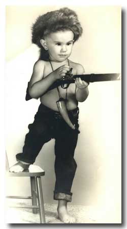
The author as a young Davy Crockett
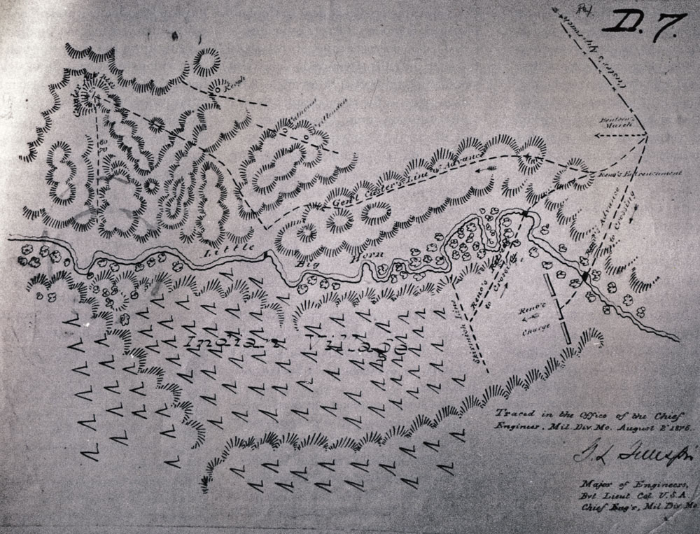
In high school, I had a Texas history teacher who introduced me to George Armstrong Custer -- rather strange since Custer had minimal experiences in Texas. Soon I found myself reading Dee Brown’s Showdown at Little Bighorn, which, as an eighteen-year-old, I thought was brilliant. Later I realized that he was a great storyteller, but a poor historian. As a romantic, my love of the tragedy in a particular San Antonio mission was replaced with that of a hillside in Montana. Searching for more books of this genre led me to The Custer Myth, making me quickly realize the contradictory nature of recorded history. I’ve been addicted ever since. B.R. It’s funny because I also recall playing The Alamo with my close friend, Alberto Ferreiro, in my backyard in Harlingen, Texas. Of course, I was Crockett and Alberto was always Santa Anna. It’s interesting how your road from Texas led to Little Bighorn. When did you first start working at the battlefield? M.D. After the National Geographic article (webmaster's note: Volume 170, Number 6 - December 1986) came out dealing with new archeology data in the mid 1980s, I wanted to work there. I picked up the phone and called the battlefield. In 1987, Neil Mangum offered me a summer position as a volunteer, which quickly turned into a seasonal position as a historical interpreter for the Custer Battlefield Museum & Historical Association. I quickly found out how much I did not know. However, Michael Moore, Cliff Nelson, Kitty Deernose, Monty Henry, and Charley Mulhair brought me up to speed. Neil was initiating a rigorous and objective interpretive program consisting of seven different lectures a day. The process was a historical orgasm and I shuddered afterward. After the canning of the CBH&MA, I was hired as a National Park Ranger -- complete with Smokey the Bear hat. I’ve been there for eighteen summers (total) and have lectured and introduced the battle story to over 500,000 visitors. B.R. How did you become interested in producing Drawing Battle Lines? M.D. During my summers in Montana, I had many opportunities to research the battlefield archives. I kept finding maps that I’d never seen before and that had not been published. There was a wealth of material, in my opinion. I always found the map notations in other author’s books superficial in their explanations and descriptions. Even Hammer’s maps by Walter Camp seemed to be missing something: organization, dates, and chronologies. I have a little Sherlock Holmes in me, and I thought that more needed to be done to catalogue and explain the significance, inconsistencies, and valuable information contained within. One map led to another. Before long, other friends called me the “map guy” and were sending Little Bighorn maps to me. B.R. These obscure battle maps are amazing. How did you even begin to locate those outside the archives? M.D. First, I methodically went through all the maps in the collection of the battlefield with the help of John Doerner, Sharon Small, and Kitty Bell Deernose. They were extremely helpful in locating maps and pulling them from the archives. I know there were days they must have said, “Oh no…here he comes again.” Historian Thomas Buecker had planned to write a book on maps and generously shared his collection with me. While I was familiar with most of the maps he had, there were several unknown to me that have become a special part of this compilation. Some images were privately housed and the owners generously allowed me to study and use them. Others were located by just good old-fashioned research and discovery. In only one case was an owner stingy with his map, but I found a copy in the battlefield archives. B.R. You open Drawing Battle Lines with the eight Edward Maguire maps. They increase in their detail of the battlefield with each edition. Why did Maguire make so many maps? M.D. Edward Maguire was the first mapper of the battlefield and the book places the maps in chronological order in each section. In reality, the Maguire maps should be called the Edward McClernand maps because Maguire took the almost completed job away from his subordinate. Maguire and McClernand both realized that some recognition would come from the task. While some see a conspiracy in his map changes, Maguire was a designer attempting to make an artistic illustration of the field. (There was a “grassy knoll” at Little Bighorn, but no conspiracy.) Maguire must have worked from extensive notes that are now lost or misplaced. After one of his maps was so severely criticized during the 1879 Reno Court of Inquiry, he was determined to make a more accurate map. This later map eventually was sent to Congress for use in the development of the Custer Battlefield National Cemetery. B.R. On George Gillespie’s map (page 80) the numbers 80 & 70 are shown along a line running from Last Stand Hill to the Deep Ravine. What is the significance of these numbers? M.D. This is a notation that I do not have an answer for. You have brought up a puzzle that is so inherent in these maps and it is my hope that other scholars will develop their own interpretation of what the information might mean or designate. I’ve found that some of these maps have created more questions for me than answers. I find it interesting that Maguire’s boss would make his own map that is incorrect in many ways, though he was not even there. I would have loved to have been a fly on the wall when Maguire and Gillespie were altering their maps. I feel certain that other drawings will be discovered – such is the nature of the never-ending Little Bighorn saga. Even after 130 years it is amazing to note the revelation of new material.
Gillespie's map has numbers 80 & 70 on line from Last Stand Hill to the Deep Ravine
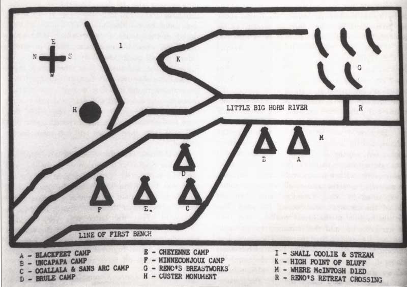
B.R. In the endnotes some maps are noted as copies held in the Little Bighorn and other locations’ archives. In those instances where only a copy of a map was used for review, do you know if and where the original exists? M.D. In a few cases I was unable to locate the originals and had to use reproductions in collections. This of course does not diminish the importance of the map, as long as the information was clear. The originals of Godfrey and Pretty White Buffalo maps are examples of sketches that I could not locate. If their whereabouts are discovered, I will be happy to include such information in future editions. I’m not embarrassed to say “I don’t know.” I look at the story of Little Bighorn as a collaborative sharing effort -- I’ve spent my career doing so.
Pretty White Buffalo map
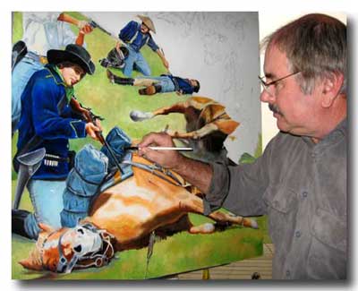
B.R. You recently told me that some private owners of a number of maps have only graciously given you permission to publish them once. Does this mean that your book might never see a second printing? If so, how many books were published in this first edition? M.D. Upton and Sons rose to the challenge of such a monumental task and published 1,000 copies. This book was truly a team effort and would not have been possible without the help of many libraries, collections, and individuals. I had to be a little masochistic to attempt such a task, as it was like a black hole -- I spent a great deal of money for reproductions, as well as usage fees. It took seven years to gather the info and still other maps kept appearing. I had to say to myself, “Stop and publish what you have.” Professionally, I am trained and educated as an image crafter, so words do not flow easily for me. I am indebted to Diane Jasmer, who helped edit parts of the manuscript. More importantly, the book would not exist without the help of my editor-in-chief and dear friend, Carolyn W. Bennett, who spent endless hours correcting and refining my thoughts. She helped in the numerous revisions that the book went through, and I was pleased with the end result. In addition, I hope the owners of the private maps will allow me to reproduce the maps again if future editions are published. B.R. Most of us know you’ve been researching and still writing your version of the battle to be published at some future date. Do you plan to tell the story of just the battle or will you also venture into the causes and aftermath of the Sioux/Cheyenne War of 1876? M.D. The causes of the war are well known and that is not news to most. Bob Utley, and most recently, Jim Donovan, have done a spectacular job of explaining the rationale and background of the battle and the Indian Wars in general. I will deal with its causes only minimally. The mystery of the battle, however, still intrigues all of us. The battle book I’m working on will deal with all of Custer’s Indians fights -- with a new approach. It will put Little Bighorn into perspective for the first time. Custer’s last fight was not a strange anomaly -- it was predictable if seen in the context of his other three fights, as I will connect all four episodes of his Indian fighting career. It will also distinguish the differences in his strategies when fighting Rebels and Indians. I will show that he based his decisions at Little Bighorn on past successes. Custer came close to orchestrating a similar success along the banks of the Little Bighorn River. B.R. There have been an unusual number of recent books on the battle; however they provide nothing new to the story. Can readers of your battle book expect something significant and if so, can you tease us with information without spoiling any surprises? M.D. The battle book will include more information than most regarding the fights in Medicine Tail Coulee and on Nye/Cartwright Ridge. I will use actual field research and timed studies that many scholars have not included. It will, of course, contain maps. The recent archeological data recovered in the 2004 road dig, like all the other digs, has altered our ideas about the fight. All this will add a fresh and controversial interpretation of the battle. It will include a common sense approach to Custer’s actions that have been long overlooked. I hope it will be original, as that is my true nature. B.R. It’s probably too soon to tell when you’ll be finished with your version of this great story, but two summers ago you told me you had Custer at the Crows Nest and last summer, if I remember correctly, you had him entering Medicine Tail Coulee. Where is Custer now? M.D. I have Custer traveling along the battle ridge going north. If you have seen my BBC docu/drama, then you might know what happens next. I’ll include a lot more evidence that was alluded to in the film, though much was cut out. Custer will die on top of a hill and not at the river, thanks to a recent discovery by my friend Bob Reece – how is that for a teaser! B.R. Now, I’m in trouble! You mentioned to me that you’re in the middle of painting your version of Custer’s Last Stand to grace the cover of your future battle book. Can you describe for us what that will look like once complete? M.D. The viewer will be in the middle of the action. Custer will not be fighting. It will include portraits of all those found on Custer Hill. It will be action packed. Yours truly will be one of the soldiers dying; just like in Eric Von Schmidt’s painting “Here Fell Custer.” The title will be “Where in the Hell is Benteen!”
"Where in the Hell is Benteen!" - photo by Carolyn Bennett
B.R. Lastly, will we see you in NPS uniform again this summer at Little Bighorn? M.D. I’ll be trying to tell the story with the same passion during summer #19. I am thankful that my boss and good friend, Ken Woody, has put up with me all these many years! I think he does an outstanding job with the interpretive program at the battlefield, and I’m always proud to represent the National Park Service. B.R. I completely agree with your comments regarding Mr. Woody. Anyone that has witnessed one of your battle talks on the patio of the visitor center will never doubt your urgency and passion in telling the story of Custer's Last Stand. Thanks for talking with us, Mike. It will be a pleasure to see you again at Little Bighorn. Good luck with Drawing Battle Lines and the future battle book.
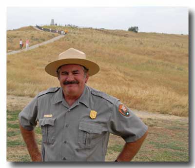
Donahue just before another Battle Talk - photo by Tim Downey Drawing Battle Lines HomeMore Of Our Interviews With Historians |
|
|||
|
Copyright 1999-2016 Bob Reece Friends Little Bighorn Battlefield, P.O. Box 636, Crow Agency, MT 59022 | Home |
Board of Directors |
Guest Book | Contact | Site Map
| |
||||